

Lake Qarun (Birket Qarun) in the Fayoum of Egypt
by Seif Kamel

Lake Qarun, located about 80 kilometers southwest of Cairo in the Egyptian Fayoum not far from the Nile Valley, is one of Egypt's most treasured natural landmarks and a resource that has helped support human culture for some 8,000 years. It is the only natural contemporary lake of any size in Middle Egypt. It is therefore rich in both natural and archaeological resources.
The History of Lake Qarun
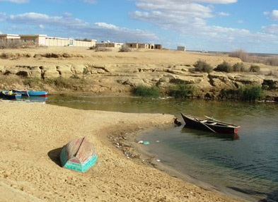
Lake Qarun is the third largest lake in Egypt and the second most famous one after Lake Nasser in the Southern part of Egypt. It lies some 45 meters below sea level and occupies the lowest, northern section of the Fayoum depression. People in Fayoum believe that if one has not visited the lake then one has not visited the Fayoum. Within the Fayoum, it is simply referred to as the Berka, which means "the small lake" in Arabic. The lake has the most beautiful picturesque views and taking a small boat on the lake is a wonderful experience.

In reality, Lake Qarun is a huge salty body of water that makes it unfit for drinking. And while its southern and eastern shores are populated, where fresh water can be brought from irrigation systems, the northern shore is bare desert, uninhibited, and difficult to reach.

The lake has an interesting history and there are some fascinating theories about how it came to be known as Lake Qarun. The lake and the nearby Qaser Qarun are said to take their names from the Greco-Roman city of Karanis to the east. However, the lake was known in the thirteenth century, some eight hundred years after the abandonment of Karanis, as Birka El Seid, or "the lake of fishing" in Arabic. Therefore, many believe that it is unlikely that Karanis would today influence the lake's name. Others claim a connection with the word Qarn, or "horn" in Arabic, and indeed E W Lane recorded in the 1820 the name of the lake as Birka Qarn. He said that it took its name from the island in the middle, which has a small horn peak. However, Lane was the only one who claimed this explanation. Travelers both before and after him gave the name of the lake as Qarun.
The most popular story is that the lake and the temple take their name from an individual who was suppose to have lived in the area, and who is mentioned in both the bible (Numbers 16) and the Quran (al-Qasas 76). In the bible, he appears as Korah, who rebels against Moses and is promptly punished by god, being swallowed up in the earth along with his entire family and possessions. In the Quran, he appears as a man exultant in his richness. It is a well known story in Egypt that this man had the ability to touch anything and turn it into gold. Some believe that his treasure is still hidden somewhere under the water of the lake. This man finally meets the wrath of god, again by being swallowed up in the earth. The Quran states that, God does not love the exultant."


An earlier, fuller, and much more revealing version of this story was recorded by the Frenchman, Paul Lukas. Riding out from Al Nazla across the desert to visit Qaser Qarun in 1714, he was told the story by his Bedouin companions. A long time ago, Caron ruled this area of what is now desert, but which then boasted many towns and more than three thousand villages. The story goes that at that time, this area had the best climate and the most fertile land in the world. However, Caron was so evil that he employed magic to bring destruction to his land and turn it into the most sterile of places in Egypt. First, he conjured up a deluge, and then, when the waters subsided, he created a great wind that brought so much sand that the whole country was buried forever, becoming a desert.

Historical Map of Lake Qarun
This particular fairy tale almost certainly has its origin in the events of the late Roman period. Many Ptolemaic (Greek) and Roman towns were situated here. Theodelphia, Philoteris, and Dionysais are all examples of these towns. Furthermore, much of the area was cultivated until the decay of the Roman Empire, when local governmental mismanagement led to the loss of good land to the desert and the abandonment of the towns. Even recent reclamation work, which has made the southwestern shore of the lake green again, has failed to make good the huge losses of agricultural land incurred during the late Roman times.
Qarun may thus have been a particularly unpopular Roman governor under whose careless rule this land was deserted, or else a fictional character epitomizing the Roman administration in general. The biblical and Quranic connections were probably added later when the similarity between the two stories was noticed.
The Modern Lake

The Qarun Lake today, 45 meters below sea level, has a surface area of 214 square kilometers. It has a maximum depth of just over 8 meters (west of Golden Horn Island) and a volume of 800 million cubic meters. It is 42 kilometers long and 9 kilometers wide at its broadest point. About 370 million cubic meters of drainage water reach the lake annually, and as the lake level now stays fairly constant and there are no known outlets, this figure is also taken as the annual rate of evaporation. If follows that, if the water supply to the lake were cut off, it would dry up in two years.
The high rate of evaporation has led to a concentration of salts, the lake is now as saline as the seawater, with a ratio of around 34.5 parts per thousand, said to be growing at the rate of 0.4 parts per year. For comparison, sea water ranges between 34 and 37 per thousand, while Jordans Dead Sea has between 300 and 330 per thousand. The water is less salty in the East and the South of the lake, where the two main canals bring in fresh water.

Large as the lake now seems, it is but a puddle compared to its former glory. It was certainly much larger in the past than it is now, but just how big and at what stages in its history are points of debate. The evidence on which the various theories are based is sometimes archaeological, sometimes historical, sometimes hydrological, and sometimes geological. Many of the locals of the Fayoum believe that the great lake and surrounding swamps were drained by the patriarch Joseph of biblical fame. The Fayoum became the land of Joseph and the canal connecting it to the Nile was Josephs water or "Bahr Yousef" in Arabic.

John Ball, in his "Contributions to the Geography of Egypt published in 1938, worked out a detailed history, which has been only minimally contradicted by more recent studies. Based on Ball's account, we believe that the Fayoum Basin was first excavated by wind erosion in the early Pleistocene period, and erosion of a side-gulley of the Nile led to the breaking of the Nile floodwater through what is now the Lahun Gap 70,000 thousand years ago. The depression filled with water flowing into the lake during the low season. Afterwards,a number of level changes occurred, linked to climatic variations, changes in the level of the Nile, or shifts in the course of the Nile. Fluctuations in Neolithic times led to the success or demise of various early agriculture or fishing communities on the lake shore.
A general recession set in around the beginning of Dynastic times, so that during the Old Kingdom, the lake may have been as low as two meters below sea level and no longer in free communication with the Nile. In the 12th Dynasty, Amenemhat I, identified with the king known to the Greeks as Lamarres or Moeris, re-flooded the lake, brining its level very rapidly up to 18 meters above sea level. He did this by widening and deepening the existing channel connecting the Fayoum to the Nile, which is now known as Bahr Yousef, and by constructing a five kilometer embankment from the northern side of the Lahun Gap at al-Lahun. Once the channel was dug, the lake probably took four or five years to fill.

An initial objective in clearing the channel may have been to drain the low-lying marshes along the Western desert edge of the Nile valley, but the net result, and probably the main purpose of the mammoth scheme, was to create an overspill for Nile floodwater , thus protecting Lower (Northern) Egypt from the disaster of excessively high floods. Then, during the low season after the Nile flooded, the lake would act as a reservoir and return the water to the Nile Valley. What Amenemhat I in effect did was to reestablish the free communication between the Fayoum Lake and the river Nile.
All of the 12th Dynasty remains located in the Fayoum stand at around 18 or more meters above sea level. The lake level fluctuated seasonally, so that the colossi of Biahmu, at exactly 18 meters, sometimes stood on dry land and was sometimes surrounded by water. The capital, Shedet ( (Kiman FGaris), which stands on high land in the southeast, remained untouched by the floodwater all year, but was its land was irrigated easily by side-cannels from the main canal with no mechanical lifting required.

The lake, known by the Greeks as Lake Moeris from the Egyptian word mer wer, meaning "great lake," still stood at around the same level or even higher when Herodotus saw it in the mid-fifth century BC, and remained apparently remained that way until early Ptolemaic times. The large scale reclamation of the Fayoum accredited to Ptolemy II was actually begun under Ptolemy I. The southern section of Amenemhat I's barrage from Al Lahun to Gebel Abu Sir was dismantled, and a new barrage was built roughly from west to east, across the mouth of Lahun gap and joining the middle of the old barrage at Al Lahun. With sluices in the new barrage across the Bahr Yousef, the flow of water into the Fayoum was now strictly controlled and only water sufficient for irrigation was allowed in. It probably took as long as 30 years to lower the level of the lake to two meters below sea level, the same level it had been during the Old Kingdom. It remained at about the same height from around 300 BC until the beginning of the Christian Period.

The Ptolemies were able to reclaim about 1,200 square kilometers of good, fertile land, and this led to an agricultural boom in the region, with large settlement programs and the founding of many new towns. Land south of the lake was basin irrigated from canals branching off from the Bahr Yusuf, while some land north of the lake was irrigated directly from the lake itself using lifting machinery.

During late antiquity many canals, including the Bahr Yousef, became badly silted up. Consequently much land was lost to the desert and the reduction of inflow caused a further fall in the level of the lake, bringing it down to 36 meters below sea level by the end of the Roman period. The salinity of the water also began to increase. By the thirteenth century, cultivation of the Northern shore of the lake had all but ceased when irrigation with lake water was no longer possible. In 1714, Lucas noted that the lake water was bitter in the west, sweet in the east. In January 1801, a Dr Martin recorded that his horses drank from the eastern end of the lake, though a day later his camels were floundering on a salt-crust at the western end. The lake at this time probably stood at around 40 meters below sea level.
Underground drainage from the lake, which acted to slow down the increase in salinity, probably stopped around 1890 when the water level came into equilibrium with the great water-sheet under the Libyan Desert at 40 meters below sea level. Salinity has increased more rapidly since that time to the extent that nearly all the original species of fresh water fish have now died out. The level of the Lake for most of the last hundred years has been carefully maintained at 45 meters below sea level.

Today, Lake Qarun is a Protected Area in Egypt, basically a national park.
For more information on the modern lake, see also: