

The Gilf Kebir, Part I
by Allan Watson

Egypt's Western Desert is full of wondrous natural phenomenon and surprises. Sometimes one wanders over a ridge or through a pass and discovers alien worlds, such as in the White Desert. Less known perhaps, but growing in popularity is the ancient plateau known as Gilf Kebir (Great Barrier), its sides now heavily eroded and penetrated by huge sand wadis and incredible dune systems which, at one point, rise 300 meters to meet the level of the plateau, an irresistible force meeting an immovable object! Amid this most awesome of natural settings, is located unquestionably one of the richest storehouses of prehistoric rock art in the world.

The Cave of the Swimmers is the most famous, but recent discoveries have revealed many other incredible sites dating back more than 7000 years, and there is certainly much more to be explored. New discoveries continue to be made, with arguably the single finest rock art site in the Sahara, the Foggini-Mestekawi Cave, being discovered only in 2002. It is now thought that the original inhabitants who created these stunning images influenced early Pharaonic cultures, and trade items have been discovered that demonstrate the links shared by these early peoples.
In certain locations one can still find Mesolithic arrowheads littering the sands, huge natural amphitheatres and, some claim, the lost oasis of Zerzura.

In recent years, Gilf Kebir has become a fairly popular Egyptian tourist destination for the more adventurous travelers, not just for the rock art and perhaps a chance to make an amateur discovery, but also for the sheer grandness of the landscape. It also shows how varied are the Egyptian antiquity sites. The Gilf Kebir is a flat-topped limestone plateau located about 150 kilometers north of Gevel Uwaynat, covering over 7,770 square kilometers. It is situated in the southwestern corner of Egypt about 720 kilometers from the Nile and 960 kilometers from the Mediterranean. Like a huge shelf the size of Switzerland, it is nearly dissected in two by a large cap. It rises 300 meters from the desert floor (1075 meters above sea level), forming one of the most formidable barriers in Africa. Dozens of wadis extend into the desert around its perimeter. these wadis were formed by water erosion in a wetter phase thousands of years ago in the late Tertiary age. Then it was a great divide, draining water in all directions, north, south, east and west.

The cliffs in the south and the southwest are the highest. The cliffs in the northeast have been broken down into small islands of land. Wind and water have combined to work away at the Gilf Kebir for over 100,000 years. Although it probably took its present form in the late Tertiary, or early Quaternary time, the only reason it is still standing is its tough cap of solidified sandstone. The northern portion of the Gilf Kebir is drowning in sand from the Great Sand Sea. It is helping the wind break down the Gilf into small islands and cones. That sand is whitish. The sand at the middle of the plateau is reddish. Wadi Hamra, as its name states, if filled with red sand. The southern portion of the Gilf is 5.800 square kilometers.
The sand on the western half of the southern portion is also red, as are the dunes to the northeast of the Gilf. Around 9500 BC, the monsoonal system shifted northward and lakes formed around the Gilf. Then, by 4500 BC the conditions were once again arid. Penderel, in a paper presented to the Royal Geographical Society in June of 1934, says that John Ball was the first westerner to see the Gilf, while on patrol in 1917. However, credit for the discovery is given to Prince Kamal al-Din, who actually reached it, skirted its southern cliffs, fixed it on the maps and named in in 1926. In 1932, an expedition was mounted to explore the Gilf by air. It included Sir Robert Clayton-East-Clayton, Count Laszlo Almasy, P. A. Clayton and Penderel. As a bit of trivia, one may note that the fictional story, the "English Patient", was based on the life of Almasy. He came from an untitled Hungarian family, but claimed to have driven the car of the last Hapsburg king, Karl IV. In return, the king made him a count.

They discovered several valleys rich with vegetation, including what would later be known as Wadi Hamra, Wadi Talh and the Wadi Abd al-Malik. These valleys were used by tribesmen for grazing and some explorers believed that they were the lost oasis of Zerzura. Archaeological work was begun in 1933 by Fronbenius, focusing on rock art. Prehistory work began with Bagnold's expedition of 1938, done by O. H. Myers and H. A. Winkler. This expedition was a joint effort of the Egypt Exploration Society, which supported Myers, Gray and Winkler, and the Royal Geographical Society, which provided grant money to Bagnold. During World War II the Italians had a base in the region, while the British set up at Uwaynat. The Long Range Desert Group of the British Army were active in the area.

The Bagnold-Mond 1938 expedition spent a month working around the Gilf Kebir. They did a huge amount of survey work, archaeology and geophysical and geological investigation. An additional month was spent at Uwaynat where Hans Winkler joined them. While Winkler was at Uwaynat, Bagnold and Peeol went north along the western side of the Gilf and found two more rock art sites, one of which was a totally new discovery. Recent exploration began with Misonne, the Belgian who crossed 600 kilometers of the high plateau in 1969. He found that sheep, foxes and lizards lived on top of the Gilf. Issawi in 1971 and 1972 did a geological survey, followed by Wendorf in 1974 and al-Baz in 1978.

Between 1976 and 1977, the Deutsche Forschungsgemeinschaft and the Academy of Sciences of Egypt launched an ongoing geological program under the leadership of Lkitzch and supported by the Continental Oil Company (CONOCO). In 1978, a new type of explorer came to the Gilf Kebir and Gebel Uwaynat, looking for answers to questions that were from out of this world. The two week expedition of seven Americans and nine Egyptians led by Farouk al-Baz was to "verify in the field interpretations of tonal variations and surface patterns observed on Earth-orbital photographs." They wanted to compare the Libyan Desert, particularly around the Gilf and Uwaynat, to photos they had of Mars.
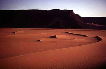
The Northern Side of the Gilf Kebir can be a bit disappointing to some, as it has broken down considerably over the years and one does not have the sense of approaching a huge plateau with many high cliffs and wadis as one does on the southern and western sides. However, there is a spectacular event taking place here. The southern edges of the Great Sand Sea have now reached the Gilf Kebir, and one can observe two great natural forces at war with each other. In two huge valleys before Lama Point they clash in an incredible phenomenon. The sand is filling up these wadis. The individual dunes climb over each other on the far side of the wadi, forming a moving ladder that eventually reaches the top in the far left corner. Here the sand spills onto Lama Point. There must be trillions of tons of sand banked up against the far wadi wall, climbing up and over and up and over, fighting its way to the top. Lima Point sits at the southwestern side of the first valley. After it, at Almasy Mountain comes the second dune filled valley. Here, too, the dunes are climbing. They look like they are eating the Gilf and they have reached the top of it here as well. During the coming decades we shall see if they succeed in breaking down the Gilf. What happens once they all reach the top is anyone's guess.

The plateau of the Gilf Kebir itself is gravelly and mostly featureless, with big slabs of basalt in some places and at least one old riverbed. The edges of the plateau are another matter. Like a voyeur, one peers into amazing worlds filled with exotic scenes. As one travels north-northwest along the western edge of the scarp, valley after valley can be seen from the top. Where the northeastern scarp has few true cliffs, just eroded hills and dune filled valleys, the northwestern side is all cliffs and spectacular views onto the Libyan plain below. Along here, there is a Black Valley, a Red Sand Dune Valley and a valley where one can walk down to the desert floor. All of these are to the south of one of the most famous valleys called the Wadi Sura, the Picture Valley of Almasy. At the extreme northern section o the Gilf Kebir stand the entrances of three wadis known as Wadi Hamra on the northeast, Wadi Abd al-Malik in the center and Wadi Talh on the northwest. These are the tree valleys that Almasy claimed were the lost oasis of Zerzura.

After the explorers saw the valleys from the air, they felt compelled to visit them on the ground. In 1933, Almasy, Dr. Dadar, a geographer and geologist from Budapest, Mr. Casparius, a photographer and cinephotographer, Dr. Bermann and Penderel journeyed to the Gilf once again. Leaving Kharga on March 22, 1933, they headed to Abu Ballas, visited Regenfeld and headed for the east side of the Gilf.
They climbed to the top of the Gif and found a camel route to the plain below. Almasy went looking for another wadi, the third, to round out Wilkinson's claim that Zerzula had three valleys. What they discovered was that the Gilf has two parts, a northern one and a southern half with a gap between them that Almasy named al-Aqaba. Upon reaching the end of the Wadi Hamra, they climbed to the top of the Gilf. They found it flat, gravelly and absolutely silent. There was no wind. They continued their journey from east to west across the top of the Gilf. By the third day they were close to the southern end, and by the fourth day they found their way down and began moving north along the eastern side.
We do not know exactly where they descended, but there they found another (unnamed) wadi and followed it for an easy ascent to the top of the Gilf once more. In one of several caves in the wadi they found rock art. The cave was large and the drawing were on the roof and consisted of longhorn cattle, men and a cave or hut with bales and bundles hanging from the roof. In 1933, on the next trip into the desert by car, Almasy talked with an old Tebu called Ibrahim Abd al-Malik, a caravan guide from Kufra who had been one of the Kufra refugees.

It was Ibrahim who called the wadi Abd al-Malik, Servant of the King. He also spoke of Wadi Talh, the Valley of Acacia. They entered the Wadi Abd al-Malik on May 3rd. It is a long valley with lots of acacia trees. There were sites of Tebu camps with grass huts and baskets. On May 5th, Almasy found a second wadi, perhaps the Wadi Talh. Then the group left for Uwaynat, where they met up with Ibrahim again. Now, the old Tebu gave up the final bit of information. There was a third valley in the group and it was called Wadi Hamra, the Red Valley (It had already been found by P. A. Clayton). Here were the three wadis of Zerzura mentioned by Wilkinson in 1830. At the lecture given by Bermann at the Royal Geographical Society, one more piece of the puzzle was finally revealed, "As to the name 'Zerzura', our Tebu friend Ibrahim, asked where Zerzura lay, said, 'Oh, those silly Arab people, they do not know anything; they call these three wadis in the Gif, Zerzura, but we local people know their real names.'"
See also: